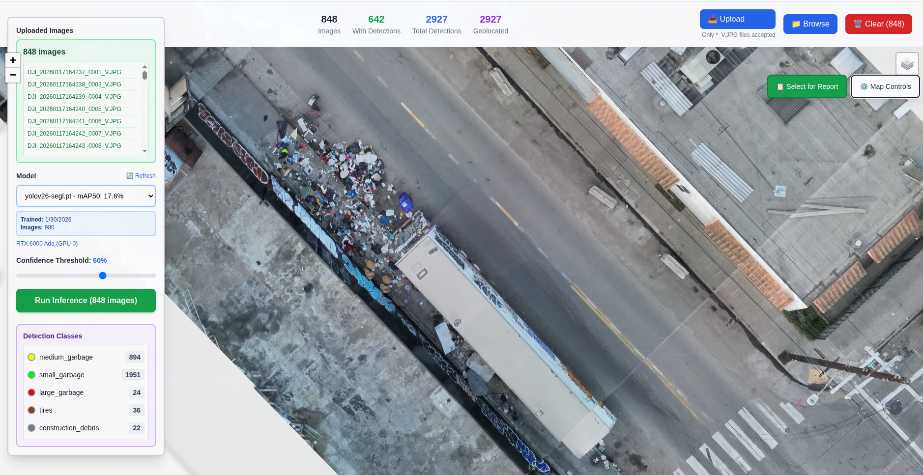
Clear your backlog. Eliminate office work managing work orders. Get ground truth daily. AI-powered aerial monitoring handles the verification so you can focus on cleanup.
Your team spends more time managing work orders than cleaning dumpsites. Backlogged tickets, field verification trips, and outdated reports consume resources while the actual problem grows.
Automated verification replaces manual field visits and paperwork. Your team gets cleanup lists, not administrative tasks.
Enterprise drones equipped with high-resolution cameras fly systematic routes covering your target areas. Daily coverage ensures nothing goes unnoticed.
Custom-trained deep learning model identifies illegal dumping materials: mattresses, furniture, tires, appliances, construction debris, and bulk waste.
Precise GPS coordinates, photo documentation, severity scoring, and change detection for every site. Know exactly where, how big, and whether sites are growing.
Integration with your city systems creates automatic work orders. Cleanup crews receive prioritized dispatch lists — no manual reconnaissance needed.
Follow-up flights provide photo proof that sites have been cleaned or were false reports. Close backlogged work orders with definitive evidence — no field verification needed.
Identify hotspots, track patterns over time, and optimize crew deployment. Data-driven resource allocation based on actual need, not just complaint volume.
Stop sending crews to verify old tickets. Stop managing spreadsheets of backlogged work orders. Aerial monitoring provides photo proof to close them all — cleared sites, false reports, or active dumpsites requiring cleanup.
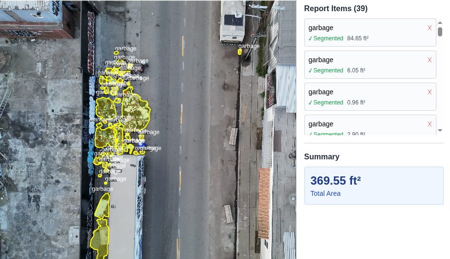
Location: 2847 3rd Street
Work Order #: 45782
Status: Site verified clean — no dumping present
Close work order with timestamped aerial photo as evidence. No field visit required.
One flight. One square mile cleared of backlogged tickets. Aerbits software automatically matches aerial photos to open work orders, providing definitive photo evidence to close every illegitimate report. No field visits, no guesswork — just proof.
Automated flights capture current conditions of reported locations. If the site is clean, you have timestamped photo evidence to close the ticket.
Not every complaint is accurate. Aerial verification quickly identifies locations where no dumping exists — close false reports with confidence.
Stop sending crews to verify old reports. Aerial coverage provides the evidence you need without dispatching trucks or inspectors.
Once the backlog is cleared, focus resources on confirmed active dumpsites. Deploy crews only where dumping actually exists.
Three automated steps from aerial photo to closed work order.
Computer vision scans aerial photos and identifies illegal dumping with 94%+ confidence. GPS coordinates, size estimates, and classifications are automatically generated for every detection.
Software automatically matches GPS coordinates from detections to open work order locations. Identifies which sites are clean, which have active dumping, and which are unreported.
Each work order receives timestamped aerial photos as evidence. Clean sites are auto-closed with proof. Active sites get updated images. Unreported sites become new tickets.
Stop spending resources on paperwork. Start deploying them on cleanup.
Close stale work orders with photo proof that sites have been cleaned or were false reports. Aerial verification provides definitive evidence for every open ticket. Clear 1,000+ backlogged tickets in days, not months.
Stop manually managing work order verification. No more dispatching crews to check if sites are still active. Automated daily flights handle verification — your team just gets cleanup lists with photo evidence.
Discover the 30-50% of dumpsites that never get reported. Environmental justice means objective coverage regardless of which neighborhoods file complaints. Every site detected, whether reported or not.
Know the actual status of every location, every day. No more working from weeks-old reports or unverified complaints. Current conditions, timestamped photos, GPS coordinates — the complete picture updated daily.
This technology has been deployed and validated in the field. In the Bayview-Hunters Point neighborhood — one of San Francisco's most impacted areas — daily aerial detection and reporting transformed the landscape.
Key insight: When detection stopped, dumping returned. Consistent detection is the key to sustained clean streets.
Let's discuss how aerial detection can transform your city's approach to illegal dumping.